Exploring the Enigmatic Destinations 7 Places Travelers Doubt Really Exist
Table of Contents
- The Underwater Waterfall Illusion of Mauritius
- Socotra Island's Alien-Like Dragon Blood Trees
- Salar de Uyuni Bolivia's Mirror-Like Salt Flats
- Zhangjiajie National Forest Park China's Floating Mountains
- Zhangjiajie National Forest Park’s Floating Mountains
- The Moving Rocks of Death Valley's Racetrack Playa
- New Zealand's Glowworm Caves of Waitomo
- The Crooked Forest of Poland's Mysterious Bent Trees
The Underwater Waterfall Illusion of Mauritius
The Underwater Waterfall Illusion off the coast of Mauritius, near the Le Morne Brabant Peninsula, is a fascinating visual trick. It's not a genuine waterfall, but rather an optical illusion crafted by the movement of sand and silt by ocean currents. These currents push the sediment down a submerged ledge, making it seem like water is falling into the depths. For the best view, helicopter tours provide the most stunning perspective, especially during the clearer weather conditions between September and December. This area, part of the island's dynamic marine ecosystem, features coral reefs that enhance the visual effect. The illusion appears as a kind of underwater curtain with remarkable depth, adding to the charm and allure of Mauritius. While similar illusions can be found elsewhere, like the Denmark Strait Cataract, the Mauritius version has a distinct quality linked to its specific geographic and marine conditions. The clarity of the surrounding turquoise lagoon also plays a crucial role, making the illusion strikingly visible. It's become a popular tourist attraction that adds to the magical character of Mauritius.
The "Underwater Waterfall" near Le Morne Brabant, Mauritius, is a captivating optical illusion rather than an actual waterfall. Ocean currents drive sand and silt over a submerged ledge, creating the visual impression of a waterfall plunging into the depths. This illusion is most pronounced in the southwestern part of Mauritius due to the steep drop-off of the ocean floor in that region.
The effect is further enhanced by the striking contrast between the shallow, turquoise lagoon waters and the deep, darker blue of the ocean beyond. This contrast makes the sediment movement appear like a substantial flow of water cascading down an invisible precipice. The deep surrounding ocean floor, with depths reaching over 3,000 meters, creates an ideal backdrop, intensifying the impression of a tremendous underwater waterfall.
The best vantage point to witness this natural spectacle is from the air, with many tourists scheduling flights solely to experience the illusion from above. The clarity of the image is impacted by local weather conditions. Strong currents and winds can dramatically influence the shape and apparent size of the 'waterfall', changing the dynamic of the illusion.
It's fascinating how this geological phenomenon fuels a rich marine environment. The sediment flow generates nutrient-rich waters, which support a diverse ecosystem of marine life in the vicinity. The illusion itself is a product of extended geological processes, including erosion and the continual shifting of sandbanks, offering a tangible display of the dynamics of ocean currents and sediment transportation. The illusion has become a popular subject in geological research, particularly concerning ocean sediment movements.
Although quite alluring, the optical illusion can be easily misinterpreted by those unfamiliar with marine geography. This emphasizes the importance of understanding the processes that give rise to such natural wonders and how they impact our perception of the environment. Satellite imagery and aerial photography have played a pivotal role in raising awareness of this intriguing feature. The use of these tools showcases how modern technology offers us a more comprehensive perspective on the intricate and captivating geological formations of the planet.
Socotra Island's Alien-Like Dragon Blood Trees
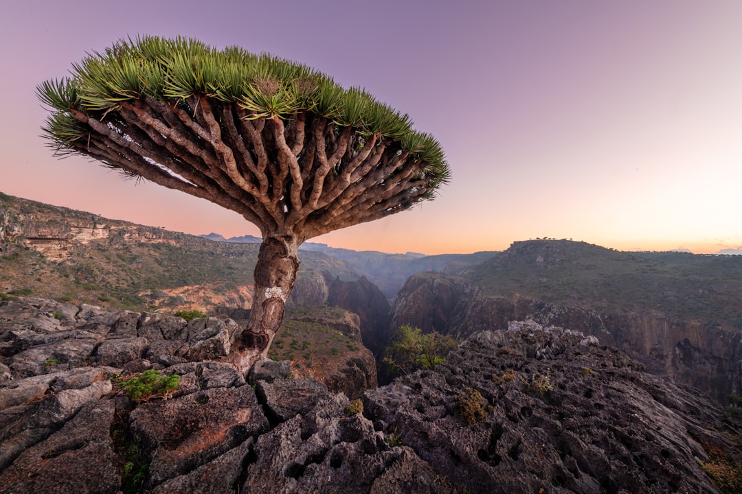
Socotra Island, situated roughly 200 miles from Yemen in the Indian Ocean, is often called one of the most otherworldly places on Earth. Its unique plant life, particularly the dragon's blood tree, contributes greatly to this perception. The dragon's blood tree, with its distinctive umbrella-like shape and vibrant crimson sap, is a key feature of the island's unique and captivating landscape. This ecological hotspot is home to a remarkable 700 endemic species, including various types of dragon's blood trees that have existed for millions of years, solidifying Socotra's reputation as "The Galapagos of the Indian Ocean."
Socotra, designated a UNESCO World Heritage Site, offers an astonishing variety of environments, from pristine beaches to towering, rugged mountains, and even hidden caves. Each distinct habitat hosts a remarkable diversity of life, many species found only on Socotra. The island's challenging environment has shaped the adaptation of its unique flora and fauna, resulting in an ecosystem that feels distinctly removed from the familiar. In many ways, venturing to Socotra can feel like stepping into a living science fiction story, a place that travelers might not believe truly exists. For those intrigued by untouched landscapes and unusual wildlife, Socotra truly offers a unique adventure.
Socotra Island, situated roughly 200 miles from Yemen's coastline, is frequently dubbed "Earth's most alien-looking location" due to its exceptional plant life, most notably the dragon's blood trees. These trees, distinguished by their umbrella-like canopies and deep crimson resin, contribute significantly to the island's otherworldly aura.
Their unique structure is a compelling example of adaptation to the harsh climate. The umbrella shape, for instance, maximizes water capture from infrequent rainfalls, a clever solution to Socotra's dry environment. The crimson sap, known as dragon's blood, has played a significant role in local culture for ages, having been employed in traditional remedies, as a dye, and in the production of varnishes. This practical usage further contributes to the mythological aura surrounding the trees.
Interestingly, the dragon's blood tree is one of around 700 unique species of plants and animals that reside on Socotra, earning it the moniker "The Galapagos of the Indian Ocean." The island hosts three distinct types of the dragon's blood trees, which have persisted for millions of years and play a crucial role in the island's delicate ecosystem. Roughly one-third of the plant species found here are endemic, a testament to Socotra's unique evolutionary trajectory.
Socotra is a haven for a diverse range of animals, too, including over 20 types of reptiles, 600 varieties of insects, and 180 bird species, many of which are unique to this island. This incredible diversity reflects the island's long isolation. The island's extreme environmental conditions, featuring a dry and rugged terrain, have resulted in remarkable evolutionary adaptations. Its unique habitats, including pristine beaches, hidden caves, and mountainous plateaus, each support distinct and fascinating types of unique flora and fauna.
Socotra has been called a "lost world" with some organisms having remained unchanged for over 20 million years. It's a destination that has captivated scientists and researchers from many disciplines for decades, and increasingly for those who are seeking a truly unique travel experience. Its status as a UNESCO World Heritage Site since 2008 underscores the global recognition of the island's remarkable biological significance and the need to protect its fragile ecosystem.
The remarkable diversity and age of Socotra's organisms highlight the need to acknowledge the delicate balance and long evolutionary history shaping this island ecosystem. While fascinating and unique, it also underlines the fragility of this ecosystem, particularly with issues like over-exploitation and habitat loss negatively impacting the trees and wildlife. The future of the Dragon Blood Tree, and the broader ecosystem of Socotra, hinges on a better understanding of its delicate balance and the importance of preserving its uniqueness.
Salar de Uyuni Bolivia's Mirror-Like Salt Flats
Salar de Uyuni, Bolivia's vast salt flat, sprawls across over 10,000 square kilometers in the southwest region, near the Chilean border. Situated at a remarkably high altitude of nearly 12,000 feet, this expansive plain was sculpted over tens of thousands of years as ancient lakes dried up, leaving behind a crust of salt. The flat's most captivating feature emerges during Bolivia's rainy season when its surface turns into a gigantic, reflective mirror. The illusion created, appearing as a seamless expanse of water, provides a unique experience, with travelers seeming to walk on a boundless, watery expanse. This almost perfect flatness, with minimal variations in elevation across its entire surface, results in incredibly dramatic optical illusions and breathtaking photo opportunities, adding to the allure for travelers.
Beyond its stunning visual effects, Salar de Uyuni represents a significant geological and ecological site, a testament to the powerful forces of nature over time. While its remarkable flatness and optical illusions draw visitors from across the globe, it also serves as a reminder of the delicate ecosystems that thrive in this high-altitude, arid environment. It's a place that pushes boundaries of perception, highlighting how certain landscapes defy our expectations and challenge our understanding of the planet, firmly cementing its place as one of the most enigmatic destinations on Earth.
### Exploring the Enigmatic Destinations 7 Places Travelers Doubt Really Exist - Salar de Uyuni Bolivia's Mirror-Like Salt Flats
Salar de Uyuni, sprawling across over 10,582 square kilometers (4,086 square miles) in southwestern Bolivia, is the world's largest salt flat. This remarkable landscape was formed over tens of thousands of years from the evaporation of ancient lakes, primarily Lake Minchin. The resulting salt crust is a fascinating geological tapestry composed mainly of sodium chloride, with layers of other minerals like lithium, potassium, and magnesium. The evaporation process left behind striking hexagonal patterns across the surface due to crystallization and the interplay of changing weather.
Beneath the vast expanse of salt lies one of the globe's most significant lithium reserves, estimated to hold roughly 7% of the world's known deposits. This has made the region a focal point for resource exploration and extraction, highlighting the economic implications of this seemingly desolate environment.
Salar de Uyuni is a photographer's dream, particularly during the rainy season. A thin layer of water covers the flat, transforming it into a gigantic mirror. This creates an awe-inspiring optical illusion—the horizon disappears, and the sky seemingly reflects onto the salt surface. The illusion is most impressive during sunrise and sunset, painting the landscape in a kaleidoscope of light.
However, visiting this unique location also presents some challenges. Sitting at an altitude of 3,656 meters (11,995 feet) above sea level, visitors need to be aware of altitude sickness. The body can have trouble adjusting to the lower levels of oxygen, resulting in unpleasant symptoms.
Beyond its dazzling surface, the salt flat is also a vital habitat for three species of flamingos—the Andean, Chilean, and James's flamingoes. These birds have uniquely adapted to the high-saline environment, relying on the algae and microorganisms found there for sustenance.
The region around the salt flat is also geothermally active. Not too far away, in places like Sol de Mañana and Potosí, you can find active geysers and hot springs—a stark contrast to the expansive salt desert. These geothermal features are a testament to the region's volcanic origins.
The cultural impact of the salt flat is undeniable. Nearby towns, such as Colchani and Uyuni, have a long-standing connection to this landscape. The local communities have built their lives around the flat, harvesting salt for generations and more recently capitalizing on tourism opportunities.
Salar de Uyuni is subject to extreme weather patterns. Temperatures fluctuate wildly between day and night, with days reaching over 20°C (68°F) and plummeting below freezing at night. These drastic shifts in temperature can create fascinating frost formations, further enhancing the unique appearance of this landscape.
Finally, the salt flat is a valuable natural laboratory for scientists and researchers. They come from around the world to study the geology, ecological adaptations, and natural resources found here. Understanding how the salts have formed, the remarkable life that thrives under extreme salinity, and the unique environment is essential to help protect and understand it better. The Salar de Uyuni stands as a testament to the power of natural processes and the incredible resilience of life in even the most inhospitable environments.
Zhangjiajie National Forest Park China's Floating Mountains
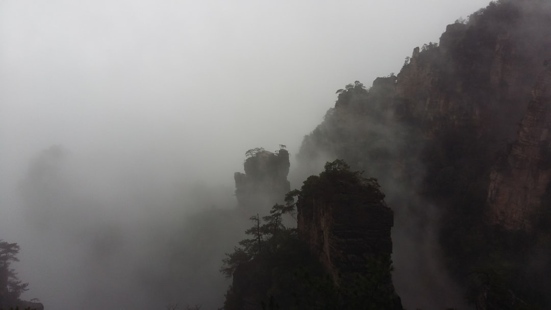
Nestled within China's Hunan Province, Zhangjiajie National Forest Park is a realm of towering sandstone pillars, often dubbed "floating mountains." These dramatic formations, which served as inspiration for the landscapes in the movie "Avatar," are a testament to the park's unique geological heritage. Designated a UNESCO World Heritage site, the park offers a captivating blend of natural beauty and adventure.
Within Zhangjiajie's boundaries, Tianzi Mountain and Yuanjiajie are prominent areas to explore. Their intricate hiking trails reward visitors with breathtaking views, revealing the park's awe-inspiring beauty. The Glass Bridge, a modern marvel that traverses the canyon, provides an exhilarating thrill for those seeking a unique perspective.
The park is best experienced during the gentler months of spring (March to May) and autumn (September to November). The milder weather during these seasons showcases a vibrant spectrum of colors as the flora blooms and foliage changes, enhancing the scenic splendor of Zhangjiajie.
For travelers seeking an extraordinary encounter with nature, Zhangjiajie National Forest Park provides a destination unlike any other. It remains a compelling destination for anyone yearning to witness a landscape that seems to defy the ordinary. It is a testament to the power and beauty of the natural world and should definitely be on any traveler's must-see list.
Zhangjiajie National Forest Park’s Floating Mountains
Zhangjiajie National Forest Park, nestled in Hunan Province, China, is renowned for its extraordinary sandstone pillars—often described as "floating mountains." These towering formations, some reaching up to 800 meters, are a marvel of nature, sculpted by millions of years of erosion and weathering. It's not surprising that their unusual shapes inspired the famous "Avatar" Hallelujah Mountains.
The park, designated a UNESCO World Heritage site in 1992, is a biodiversity hotspot, harboring over 3,000 plant species and diverse animal life, many unique to the area. The diverse ecosystems within the park, influenced by its varying altitudes, have been a subject of numerous ecological studies.
Adjacent to Zhangjiajie is Tianmen Mountain, home to the world's longest cable car ride. This remarkable engineering feat not only provides spectacular views but also offers access to tourist attractions like Tianmen Cave, locally known as "Heaven's Door." It's an intriguing blend of natural wonders and human ingenuity.
Further pushing engineering boundaries is the Zhangjiajie Glass Bridge. This structure, completed in 2016, boasts the distinction of being the world's longest and highest glass bridge, stretching across a canyon. It's a testament to the intersection of human engineering and nature's spectacle—a daring attraction for those who seek thrilling experiences.
These "floating" peaks are part of a geological feature known as "fenglin", translating to "wind forest." The story of their creation dates back millions of years to the uplift of the region, followed by erosion that shaped the dramatic cliffs. The process involved both the carving by water and weathering.
The park's dense forests serve as a significant biological carbon sink, absorbing vast amounts of atmospheric carbon dioxide. Research has illustrated their critical role in regulating CO2 levels, showcasing the importance of such ecosystems for mitigating climate change.
A network of pathways and cable car systems allows visitors to explore the park's elevation changes. The engineering challenges of constructing these structures while preserving the natural landscape are remarkable.
Beyond the geological marvels, Zhangjiajie's history is rich with folklore. Local legends abound, with tales of mythical creatures said to roam the peaks, adding to the mystical aura that surrounds the area.
Finally, the park's varying altitudes, from 200 to 1,200 meters, create distinct climates. This contributes to the remarkable biodiversity observed, with subtropical flora at lower elevations transitioning to temperate varieties higher up. The diverse habitats within Zhangjiajie paint a vibrant picture of the region's ecological diversity and resilience.
The Moving Rocks of Death Valley's Racetrack Playa
Death Valley's Racetrack Playa is home to the enigmatic "moving rocks," a geological puzzle that has captivated researchers and visitors for over a century. These rocks, primarily composed of dolomite and syenite found in the surrounding mountains, seemingly glide across the dry lakebed, leaving intriguing trails in their wake. For years, the mechanisms behind their movement remained a mystery, until recent scientific observations suggested a plausible explanation: thin sheets of ice, formed during the winter months, are pushed by mild winds, propelling these stones, some weighing as much as 700 pounds, across the playa.
The remoteness of Racetrack Playa within Death Valley National Park only amplifies the sense of wonder surrounding this natural phenomenon. The stark beauty of the dry lakebed, combined with the mystery of the moving rocks, makes it an alluring destination for those seeking experiences off the beaten path. While the scientific community continues to study this captivating geological event, it's a place that serves as a constant reminder of the surprising and powerful ways nature shapes our world. It is certainly a site that will leave a lasting impression on those fortunate enough to witness it.
The Racetrack Playa in Death Valley National Park presents one of nature's most baffling spectacles: rocks seemingly moving across a dry lakebed, leaving trails behind them. This phenomenon has fascinated researchers and tourists for well over a century.
Initially, the mechanism behind these “sailing stones” was a complete mystery, with early observations in 1915 fueling speculation about supernatural or even human intervention. However, recent scientific inquiries, notably the deployment of GPS technology in 2014, have revealed the intriguing secret. It seems that a delicate interplay of weather conditions is responsible for the movement.
During the cold winter months, thin sheets of ice form on the surface of the playa, a surface composed of fine silt and clay, often compared to a marshmallow-like consistency. As temperatures rise, these ice sheets begin to melt, turning the surface into a slick layer of mud. Gentle winds, then, push the floating ice panels, which are occasionally embedded with rocks, leading to the rocks sliding across the surface.
These rocks, some of which can weigh up to 700 pounds, leave remarkably detailed trails that can persist for years. The tracks vary significantly in length, sometimes stretching for over 1,500 feet, and can even exhibit curves and arcs, offering a fascinating record of their journeys.
The Racetrack Playa itself resides in an extremely harsh environment, one of the hottest places on Earth with summer temperatures reaching above 120 degrees Fahrenheit. This adds another layer of intrigue, demonstrating the interplay between extreme weather conditions and the subtle movements of nature.
While the scientific explanation for the movement of the rocks has offered a rational explanation, it hasn't entirely extinguished the fascination with this oddity. The folklore and local legends that surround the Racetrack Playa remind us of how humans have always sought to explain the unexplainable. It showcases that the urge to understand our world leads to both rigorous scientific investigation and imaginative stories that try to make sense of the unknown. The Racetrack Playa is a stark reminder that even in seemingly desolate landscapes, nature presents events that continue to inspire both wonder and inquiry.
New Zealand's Glowworm Caves of Waitomo
New Zealand's Waitomo Glowworm Caves are a truly enchanting natural wonder, famed for their unique glowworm populations. Located in the King Country area of the North Island, these caves have become a major tourist attraction. The caves are home to the Arachnocampa luminosa, a species of glowworm exclusive to New Zealand. Their luminescence transforms the underground environment into a mesmerizing spectacle, frequently described as a 'galaxy of tiny living lights'.
Visitors can embark on guided tours that provide interesting information about the history and science of the glowworms, adding depth to the experience. The most popular attraction in the Waitomo Caves is a boat trip through the Glowworm Grotto. This quiet boat ride allows you to glide beneath thousands of these luminous insects, creating a truly remarkable experience. Access to the caves is easy, with a scenic drive from Auckland being a common way to arrive.
Waitomo has been a tourist attraction since the late 19th century, demonstrating that this type of experience has long been appreciated. The glowworms and caves have earned a prominent place in New Zealand's heritage and tourism, attracting visitors who seek experiences that blend both natural beauty and captivating adventure. They certainly showcase a part of the natural world that many travelers might not have previously considered and help New Zealand stand out among travel destinations.
The Waitomo Glowworm Caves, nestled in the King Country region of New Zealand's North Island, are a captivating testament to the wonders of nature. These caves, primarily frequented due to the presence of the *Arachnocampa luminosa* glowworm, offer a unique biological spectacle. The glowworms, in fact, are not worms but the larval stage of a uniquely New Zealand fly species. Their bioluminescence, a fascinating chemical reaction, is a natural tool for attracting prey—a miniature light show within a dark, humid cave environment.
These caves represent a distinctive ecosystem, where the glowworms thrive in specialized conditions. The constant temperatures and humidity play a vital role in their lifecycle, shaping a delicate balance of life. The cave's very structure is also a subject of geological interest, formed from carbonate deposits compacted over millions of years. These sediments created the limestone structures seen in the caves, further enriched by the slow but steady formation of stalactites and stalagmites – evidence of a long, fascinating geological past.
Interestingly, the density of the glowworms sometimes creates a spectacle of natural lighting, illuminating the cave interiors in a way that mimics a night sky, all within the context of the cave's geological formations. The caves, unsurprisingly, have become a major tourist attraction, with approximately 250,000 visitors annually drawn to this unique spectacle. Guided tours and boat rides within the cave systems offer a glimpse into this underground world, blending educational experiences with the aesthetic wonder of the cave's formations.
The surrounding region also harbors signs of geothermal activity, which indirectly impacts the environment within the caves. The heat and minerals introduced through groundwater seem to be essential for the glowworms, contributing to the cave's unique conditions. Research has also shown that even a minor environmental change like light pollution can significantly disrupt the glowworms' bioluminescent capabilities, underscoring the delicacy of this ecosystem.
Moreover, the caves are embedded within the cultural narrative of the Māori people, who hold the caves in high regard as sacred spaces. Their legends and stories woven around the glowworms contribute to the area's historical and cultural importance, enriching the overall experience for visitors. The Waitomo Caves stand as an extraordinary blend of natural beauty and scientific curiosity, showcasing a complex ecosystem that can both awe and educate those fortunate enough to witness it. This interplay of the natural world and human appreciation offers a reminder that even seemingly unremarkable places like caves can harbour fascinating phenomena that require study and protection.
The Crooked Forest of Poland's Mysterious Bent Trees
Nestled in West Pomerania, Poland, near Gryfino, lies the Crooked Forest, a peculiar sight of roughly 400 pine trees with unusually curved trunks. These trees, planted around 1930, seem to bend at a 90-degree angle near their base, giving them a distinct and almost comical appearance, often described as "potbellied stick figures." While the most common theory attributes their shape to human intervention—perhaps farmers trying to shape timber for specific uses—the exact cause of the curvature remains a mystery.
Despite numerous investigations, scientists haven't reached a conclusive explanation. This unsolved riddle contributes significantly to the forest's allure, drawing travelers and photographers who are captivated by its strange beauty. The tranquil surroundings of the forest further enhance the experience, making it an appealing spot for nature lovers seeking Poland's less-explored treasures.
The Crooked Forest stands as a fascinating example of nature's oddities, reminding us that even in familiar landscapes, surprising and unexplained phenomena can exist. For those looking to discover something truly unique and captivating on their travels, the Crooked Forest delivers an experience that's both intriguing and memorable.
The Crooked Forest, also known as Krzywy Las in Polish, is located near the town of Gryfino in West Pomerania, Poland. It features roughly 400 pine trees with an unusual 90-degree bend at their base, creating a rather curious, almost comical, silhouette. These trees were planted around 1930, but the exact reason for their peculiar shape is unknown. The most plausible explanation is human intervention. Local farmers might have intentionally manipulated the trees during their early growth phases, perhaps to shape the wood for specialized purposes, like creating curved furniture or boat components.
The Crooked Forest is a popular tourist destination and has been featured in various media outlets, such as the History Channel's "UnXplained," further boosting its reputation for its enigmatic appearance. However, the scientific community hasn't found a definitive answer to the cause of the trees' bending. It has spurred further interest in tree growth and environmental influences in the region.
The sandy soil conditions and microclimate could have also contributed to the trees' form. The forest's unique ecology is under observation by scientists to understand how local soil, weather patterns, and other environmental aspects may have interacted with the trees' growth. The forest has been designated a natural monument, which signifies its unique character and the need to preserve its ecological qualities. The trees have even been metaphorically described as "potbellied stick figures," highlighting their unconventional appearance. It's a prime example of how nature can, or perhaps can't, be shaped by human intervention.
The Crooked Forest, embedded in a peaceful natural environment, attracts nature enthusiasts, adventurers, and individuals intrigued by unexplained phenomena. While the exact reason for the bent shape remains unknown, the forest is certainly a captivating, curious reminder of nature's idiosyncrasies and perhaps a bit of human intervention. The forest has become a popular spot for photographs, drawing curious visitors who want to witness the trees' singular beauty firsthand. Local legends about the trees add to the area's appeal, illustrating how the unexplained inspires cultural narratives and beliefs. The forest, also a subject of study, demonstrates how even unusual formations can drive scientific curiosity.
The development of the surrounding area for tourism emphasizes the influence that natural wonders can have on society, creating economic benefits and stimulating travel infrastructure. The Crooked Forest, an enigmatic location of bent trees, stands as a prime example of nature's intriguing ability to surprise us, in addition to maybe a dash of human creativity.